
since 2010
Faroe Islands Self-Drive Tour
Return to tour list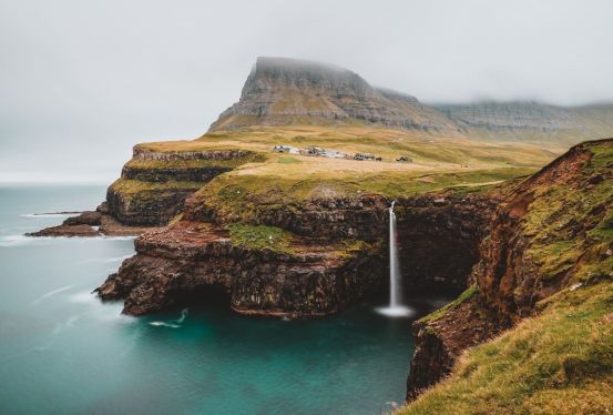
- hotel
- restaurant
- directions_car
- directions_boat
- terrain
May-September
Faroe Islands Self-Drive Tour
Day1 Torshavn
-
Flight
-
Drive
-
Drive
-
Check-in
-
5 nights with breakfast and cancelation option1 660 EURNumber of stars:Guest rating: 8.8
-
Opening hours: Mon-Fri 9-17, Sat 10-17, Sun 12-17
-
With nearly 20,000 residents, Torshavn, the largest city in the Faroe Islands, might seem small but covers 172.9 square kilometers. Situated on the east coast of Strymøy, the archipelago's largest island, Torshavn has historical significance as the starting point of the Faroe Islands' modern history in the 9th century. The Norwegians, engaged in sheep farming and trade, settled here. The city serves as an essential port and international transportation hub, with ferry connections to other islands, Denmark, and Iceland. The airport near Torshavn provides international connections. Tourists are drawn to the traditional architecture, particularly in the old part called Tinganes, along with museums, galleries, and the University of the Faroe Islands, teaching in the Faroese language.
Day2 Vágar island
-
Drive
-
Max. group size: 16Guiding language: Dansk, English, FaroeseGet ready for two of the most famous attractions in the Faroe islands at the same time. The sea-stacks Drangarnir and Múlafossur Waterfall. This boat tour wil give you an unforgettable view and memory of a lifetime.
And if the weather permits, you can be one of the very few that sail through the arch in Stóra Drangur.
The larger of the two sea-stacks. -
Drive
-
Drive
-
Hiking fee (payed cash)27 EURDifficulty level: medium
This is one of the most beautiful and most popular hike in the Faroe Islands. When you are at the cliff’s edge, the whole scenery turns into an optical illusion as the lake seems to be elevated much higher from the sea than it in fact is. A mesmerising feat of nature.
There are great opportunities to sit down on the rocky ground and simply enjoy the sight. Expect to see lots of birds flying above your head and also underneath you. You will have a blast watching the sea stretching endlessly across the horizon. When the wind is howling, everything gets more moody. You will hear the waves roaring when crashing agains the black basalt.
In order to get to Trælanípa, you will hike for one hour each way. The hike is an easy one. There is almost no elevation along the route. You will get to a gentle slope just before reaching the destination. -
Mulafossur Waterfall stands as the Faroe Islands' most renowned and awe-inspiring natural wonder. Cascading streams of water descend from the vibrant green cliffs into the tumultuous sea in the secluded village of Hasadalur on Vagar Island.
During windy days, the waterfall's water is known to rise into the air—a phenomenon typical across all the Faroe Islands. Conveniently, there is a parking lot in close proximity to the waterfall. A brief 2-minute walk from the parking area leads you to the breathtaking sight of the waterfall plunging into the ocean.
-
Drive
-
Difficulty level: Easy
Trøllkonufingur, situated on Vagar Island in the Faroe Islands, is a towering rock formation with a sharp peak that reaches 313 meters above the sea.
Translated as "The finger of the witch," Trøllkonufingur not only serves as a geological landmark but also has its roots in a local legend. According to the folklore, Trøllkonufingur is believed to be the finger of a colossal witch who ventured to the Faroe Islands with the intention of tossing them northward to Iceland. The tale suggests that her mission was unsuccessful, and she, instead, transformed into stone near the shore, influenced by the sun's rays. The legend further narrates that due to her immense size, she toppled into the ocean backwards, leaving only her finger protruding from the water, giving rise to the distinct formation known today as Trøllkonufingur.
-
Drive
Day3 Streymoy and Eysturoy islands
-
Drive
-
The boat tour to the birdcliffs and grottos near Vestmanna is one of the oldest tourist attractions in the Faroe Islands. On this 90 minutes tour you will get close to exotic birds, you will see sheep grazing on what seems like vertical fields several 100 meters over your head, and you sail into deep grottos and around high-rise free standing sea stacks, carved and shaped by nature through millions of years.
The guide onboard will explain to you, how these birdcliffs used to serve as a source of food in the old days, and how the Faroese still today gather their sheep on the inaccessible, steep mountain sides.
-
Drive
-
Kvívík, situated in a scenic valley on Streymoy island in the unexplored Faroe Islands, boasts a historical legacy dating back to the Viking era.
Along the seaside, you'll encounter Viking excavations, marking the village as one of the earliest settlements in Kvívík's history. Its tranquil ambiance and historical significance make it a favored destination for those embarking on a road trip across the archipelago.
Before reaching Vestmanna, taking a pause in this village is highly recommended. The colorful houses lining the stream, coupled with breathtaking coastal views, add to the charm of this serene settlement.
-
Drive
-
Black sand valley fee10 EUR
Nestled on Streymoy Island in the rugged Faroe Islands, Saksun is a secluded village renowned for its breathtaking setting above a mesmerizing lagoon, surrounded by awe-inspiring mountains and numerous waterfalls.
The main attraction in Saksun is a picturesque panoramic view of the lagoon, once a natural harbor, now replenished twice daily by seawater from the North Atlantic Ocean.
The Dúvugarðar settlement within Saksun adds to its allure, featuring delightful turf houses set against the backdrop of stunning waterfalls cascading down the steep hillsides. The overall experience of Saksun is marked by a unique sense of remoteness, creating an indescribable charm that captivates every visitor to the village.
-
Drive
-
"Fossá" in Faroese translates to "river with waterfalls," a term used for various streams across the islands. While the islands boast numerous waterfalls, some smaller streams have created even taller cascades than Fossá. However, Fossá holds the distinction of being recognized as the largest waterfall in the region, with a combined height of 140 meters when considering both cascades.
-
Drive
-
Tjørnuvík, pronounced 'Chu-nu-vik,' stands as the northernmost village on Streymoy Island in the Faroe Islands, nestled in the solitude of the North Atlantic Ocean. Tjørnuvík is peacefully ensconced in a deep valley, with no other villages in sight.
Comprising no more than 55 houses, the village is adorned with numerous small streams cascading down the mountains, creating an especially impressive spectacle on rainy days. Tjørnuvík is a destination that travelers consistently find worthy of prioritizing during their Faroe Islands vacation.
Most days in Tjørnuvík are characterized by skies hovering above the village, courtesy of the surrounding towering mountains. Notably, during the winter months, the sun remains concealed, unable to ascend above the steep mountainous terrain.
-
Difficulty level: medium
Risin & Kellingin are two impressive sea-stacks in the untamed Faroe Islands. Situated off the coast of Eysturoy island, far from the crowds, these basalt rock formations offer a captivating spectacle. Translating to "the Giant and his Wife," Risin & Kellingin are a must-see destination when exploring the Faroe Islands.
-
Drive
-
Gjógv, located on Eysturoy's northeast tip in the Faroe Islands, is a village named after a 200-meter sea-filled gorge leading to the sea. Established around 1584, it has sustained itself through fishing and selling dried fish. With a population decline in recent decades, it now houses a concrete elements factory, fish farm, guest house, and campsite.
The village features a church from 1929, a sculpture memorializing lost fishermen, a school building dating back to 1884, and a renovated dance hall serving as a community center. The natural harbor of Gjógv is known for its outstanding scenery, attracting tourists and boating enthusiasts. The village also boasts the only operating railway in the Faroe Islands, an incline railway transporting goods from the low-level harbor to the upper village.
Surrounded by stunning mountains and valleys, Gjógv offers a glimpse into the Faroe Islands' picturesque landscapes, with peaks like Slættaratindur and Gráfelli to the north and west. The village has historical connections, including a visit by Danish crown prince Frederik and Crown Princess Mary in 2005.
-
Drive
Day4 Mykines, southern Streymoy and RIB-safari to Hestur island
-
Drive
-
Difficulty level: EasyLength: 4 km
Explore the captivating puffin island of Mykines during the summer months in the Faroe Islands.
Please note that for the 2023 season, the path to the lighthouse on Mykineshólmur is closed due to a landslide. Despite this, you'll still have the opportunity to observe puffins up-close during your visit to Mykines.
Upon arrival on Mykines, you'll have a 6-hour stay on the island. Your time on Mykines includes a hike, ample puffin watching, and a chance to enjoy coffee at the local Mykines café before returning to Vágar island.
-
Drive
-
вхід у традиційне фарерське житло Roykstovan7 EUR
Kirkjubøur, one of the Faroe Islands' oldest and most historic villages, was once the religious and cultural center with the bishopric located here. Nestled in a fertile land with ample sunlight, the village's favorable conditions have made it a valuable and historically significant residence. While it has been more extensive in the past, Kirkjubøur remains a noteworthy village at the heart of the country.
The kings' farm, dating back to the 16th century, is the largest in the Faroe Islands and has charming, distinctive houses, including a centuries-old log house and roykstova, serving various purposes. Kirkjubø boasts the famous old cathedral wall of St. Magnus Cathedral, with its remarkable story, and is home to the oldest church in the Faroe Islands, the current parish church.
-
Max. group size: 12This round trip from Gamlarætt in Streymoy to the island of Hestur includes sightseeing around the island. Slowly we move as near as possible to the birds under the cliff, Loftið, which vertical wall measures some 1,200 feet.
Hestur harbours guillemots, puffins, black guillemots, shags, fulmars and eiders. A couple of seal caves are there as well.
If the weather is good, we also sail into the caves, Álvagjógv and Klæmintsgjógv. Current and wind directions decide which way we sail around the island. -
Drive
Day5 Kalsoy and Borðoy islands
-
Drive
-
Difficulty level: Moderate
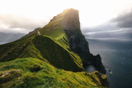
Kallur Lighthouse stands as one of the captivating landmarks in the stunning Faroe Islands. Situated on the slender Kalsoy Island, the views from this location are truly extraordinary.
Perched on the northernmost tip of the island, the small white and red lighthouse has become increasingly popular since its construction in 1927. To fully experience this attraction, dedicate an entire day to your visit. Getting to the lighthouse involves a short ferry ride, a drive through narrow tunnels, and finally, an hour-long hike.
Embark on your hike from the village of Trøllanes, and allow an hour for the trek to Kallur Lighthouse, and another hour for the return journey. The hike is of moderate difficulty, starting with a slightly steep ascent that poses no real challenge. Follow the sheep path until you reach the breathtaking scenery surrounding the lighthouse.
Most hikers will find the trail quite manageable, and the stunning views at the journey's end make every minute of effort well worthwhile.
-
Drive
-
Difficulty level: medium
Klakkur, situated on Borðoy Island, stands as a breathtaking panoramic viewpoint in the nature-rich Faroe Islands. The vistas from this spot are some of the most stunning in the entire archipelago.
Reaching the rewarding view at Klakkur demands minimal effort, making it an ideal destination for a serene evening hike and the perfect vantage point for captivating sunsets.
From the mountain ridge, one can behold the entire expanse of Kalsoy Island and the captivating front of Kunoy Island.
Distance: 6.2 km round trip
Elevation: 277 meters
Difficulty: Easy-Moderate -
Drive
Day6 Returning home
-
Check-out
-
Drive
-
Drive
-
Flight
- hotel
- restaurant
- directions_bus
- directions_boat
- record_voice_over
- terrain